* Start page * Latest news * The races of Aleder * Countries * Maps of Aleder * Site map and info *
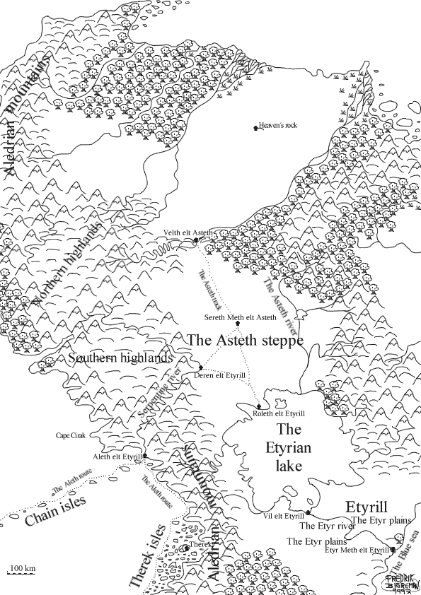
IntroductionNorthern Aleder is the heart of the Etyrian Empire, as well as the home of the elven kingdoms. Aledrian mountains, theThe mountain range stretching in north-south direction along the western coast of Aleder. It is in many areas very steep and difficult to pass.Aleth elt EtyrillThe starting point for the western and southern Aleth route and the westernmost city in Etyrill. It is sometimes called "The western gate of Etyrill". Being Etyrill´s only city on the western coast, it has got a large garrison and well kept city walls; the inhabitants are more than aware of the unknown power only a dozen kilometres north. The north side of the cape on which Aleth is built serves as main base for Eth Etyr´s Western sea fleet. Today, the fleet is mainly used for escort along the Aleth route. A large number of ships have been pulled up on land and are slowly coming apart; they came here from far provinces during the decline, and today no-one needs them.Aleth route, theThe route going west from Aleth along the Chain isles and south along the coast. The two parts of the route are usually called the western and southern route.AstethThe province immediately north of Etyrill consists of the Asteth steppe and nearby areas. The population is nomadic, and the Etyrians have never had any success in changing their lifestyle, they contended with putting taxes on the inhabitants and station a small garrison at Sereth. From the Etyrian point of view, Asteth is one large pasture for cattle, the soil is too poor to support farming. This, in combination with the lack of building material, has degraded Asteth to something separating Roleth and Velth.Asteth river, theForms the eastern edge of the Asteth steppe. On the eastern bank of the river the terrain is considerably more hilly and wooded.Asteth route, theRoute stretching from Velth to Roleth via Sereth.Asteth steppe, theOften called the sea of Grass, and is inhibited by different cattlebreeding nomadic tribes. Stretches in east-west direction from the Asteth river to the Aledrian mountains, and in north-south direction from Velth to the Etyrian lake.Blue Sea, theThe Blue Sea is named after the crystal-clear blue colour the water has on the Etyrian coast.Cape CirakThe cape is named from the admiral Miro Cirak, who led the first Etyrian mapping expedition northwards along the western coast of Aleder. The members of the expedition were the first Etyrians to encounter "The curse of the Aledrian mountains". Cirak was halted a few kilometres north of the cape by two unidentified ships. When he by means of signal flags tried to communicate, the ships opened up fire with guns, an invention still unknown to the rest of the world. Cirak lost more than half of his fleet during the escape. All later Etyrian attempts to sail north have met similar fates, lacking guns, the Etyrians don´t stand a chance against the unknown opponents. In Eth Etyr, nothing is known of the coast north of Cape Cirak. Expeditions on land have simply disappeared beyond the same invisible line, and also when trying to move west beyond the highlands. "The curse" is known in all of Eth Etyr.Chain islesA string of islands connecting Aleder and the continent to the west. The western Aleth route goes along these isles.Deren elt EtyrillThe gathering point for all goods heading down the Serpentine river. The city has a large harbour and was one of the mightier independent cities in the Serpentine valley before it was incorporated in Eth Etyr. People in the area still rather call themselves Derens than Etyrians, and the same thing goes for most of the previous city states of the valley.Eth Etyr ("The empire of Etyr")The areas more or less directly controlled from Etyr Meth elt Etyrill. Few people except the nobles of Eth Etyr uses the name in that meaning, usually Eth Etyr symbolises the empire when it was on its peak. Today's empire is then usually called Etyrill after the original province. Eth Etyr is ruled by the emperor, the oldest person in the royal family, and the Council, consisting of deputies from all noble families.Etyr river, theThe outflow of the Etyrian Lake is a very wide river, in places up to two kilometres. The river is the most important transport route in Etyrill, since Etyr is situated in the outflow to the Blue Sea. The river also, through a vast system of canals, provides water for large parts of the farms on the surrounding plains.EtyrillEth Etyr's original province and the home of all Etyrians. Consists mainly of fertile plains that are largely cultivated. Etyr is the largest city.Etyrian lake, theThe largest lake in Aleder, taking its water from some of the most water-rich rivers of the continent.Etyr Meth elt Etyrill ("Etyr, capital of Etyrill")Capital of Eth Etyr and the province Etyrill. Most people, except the Etyrian nobles who finds it barbaric, skips the "Meth elt Etyrill"-part and simply call the city Etyr. The same thing goes for the names of all Etyrian cities, the part after the "elt" (meaning "of" or "in") is usually skipped. Etyr is built on a large island in the outflow of the Etyr River and is the largest and most important city in Eth Etyr. The city occupies the whole island, but many of the houses are abandoned, in bad shape or in ruins, one of the many signs of the decay of the empire. The Etyr River is wide on both sides of the island, and there are no bridges. Transports over the river are made with large flat-bottomed ferries. This, combined with the high city walls, makes the city very easy to defend. Almost the whole southeastern side of the island is taken up by the harbour, which is protected on the seaside by a walled pier. Large parts of the defences are also in bad condition. The nobles are trying to maintain the picture of Etyr as the foremost city of the world; the defences around the gates and harbour are maintained and always manned, as is parts of the palace and most of the larger streets.Etyr plains, theThe breadbox of Etyrill, and the most cultivated area of the empire. The plains are one of the areas where the decay is least notable, the vast canal systems are still mostly in use, the large difference is that more of the production is exported instead of remaining in the same country. On the plains, there are no such things as villages, there are farms. Etyrian nobles and rich farmers own all the land, and the workers live on the huge farms. Most of the Etyrian nobility own large properties on the plains and many of the noblemen have grown up there.Heaven's rockOne of the few important places in the Elven kingdoms ever seen by Etyrians. It is a steep hill rising from the surrounding plains. The rock is black, jagged and very hard. The Elves hold the mountain for sacred, and have built a city at the western side of the rock. From there, a road has been carved out from the rock to the top. There, the human soldiers were blessed in a ceremony before they went out in the Elven Wars. The city, too, seems to be made up mostly of temples, and has few inhabitants. There seems to be ruins of another city on the eastern side of the hill.Northern/Southern highlandsRoleth elt EtyrillThe largest seaport on the northern side of the Etyrian Lake and gathering point for all cattle herded down from the Asteth steppe. Nomads from the southern parts of the steppe come here to trade their cattle for things they can't produce.Sereth Meth elt AstethCapital of the province Asteth and the smallest province capital of Eth Etyr. The "city" is made up from the garrison and a handful of official buildings in the middle of the steppe. Since the local population is nomadic, only Etyrians live in the city. Sereth is, being the closest "backwater" in the empire, a dump for state employees who have made themselves unwanted among their superiors. "Do that, and send me a letter when you get to Sereth", is a frequent joke in those circles. The only thing, apart from the caravans using the Asteth route, keeping the city alive is that cattle taken as taxes are collected here to be herded south.Serpentine River, theThe valley of the Serpentine River is famous for its vineyards, and wine is the main export of the valley. The river is the main mean of transportation, and goods going to Aleth are usually transported this way. In the northern part of the area mining is a growing industry. Before the days of Eth Etyr, the valley was parted between several city-states, the mightiest one being Deren. When Eth Etyr started expanding westward, the valley had just seen one of the larger wars between its cities, and both winners and losers were easy preys for the Etyrian army. Even after all time of Etyrian rule, the times of the city-states are remembered, and people often think of themselves as inhabitants of the city-states instead of Eth Etyr.TherekThe exact location of Therek is a well kept secret, but every seafarer has heard of the city. Therek serves av base and hideout for all pirates in the area around the Therek islands. No-one who isn´t a pirate has ever seen Therek and left alive, but the city is said to be full of all kinds of treasure. The pirates in the area are relatively well organised under a leader who traditionally goes by the name of Therek the Firece. A new Therek is chosen when the old one dies, and Therek gets a share of all booty taken. In turn, Therek is supposed to organise the plunder and make sure the pirates get information on transports and contacts for selling of booty. In all, Therek disposes about a dozen ships with crews, even if rumors and tales claim that there are so many pirates that the islands are sinking under the weight. A few of the ships are used for transports to and from traders in stolen goods. These ships never take part in any raids and sail under false flag with false papers.Therek islesThe Therek isles are every seafarer's nightmare; a huge archipelago with thousands of small isles, sand banks and grounds. There are no known charts over the Therek islands and no maps either. The reason is simple; the pirates controlling the area attack plunder and kill or hunt any trespasser to flight. The isles were discovered during the expansion of Eth Etyr and were first named the Labyrinth isles. Because of the many grounds and narrow passages between the isles, no extensive exploration was made. The vegetation on the isles and the coast is also very rough, and the area was classed as uneconomic to colonise. Later, when the southern Aleth route became more frequently used, the uninhibited and unmapped isles began to attract the interest of pirates. A captain called Therek the Fierce, is supposed to have mapped the archipelago and to have built a base somewhere in the labyrinth. The isles soon became known as the Therek isles, after the captain, whose head would generate a considerable amount of money in Eth Etyr. According to the stories, Therek is still alive, and his city is filled with stolen treasure. All Etyrian attempts to explore the archipelago or hunting down the pirates have ended in various sizes of disasters. Warships and soldiers have disappeared into the labyrinth never to be seen again.Velth elt AstethVelth marks the northern border of Eth Etyr. The city guards the southern entrance of the narrow Pass of Salvation, north of which starts the elven territories. Positioned as it is, Velth is heavily fortified and its defences and defenders are kept in good condition. The hills to the west are rich in gold deposits, but the close proximity to the elves has put an abrupt end to all attempts at large operations. The area keeps attracting gold miners though, people hoping to make their fortune and get away with it. Some do, others don't ... Velth also has the same function to the nomads of the northern parts of the Asteth steppe as Roleth has to the south. The nomads come here to trade cattle for other things.Vil elt Etyrill |
* Start page * Latest news * The races of Aleder * Countries * Maps of Aleder * Site map and info *